Archive for Projecten
De Rode Waterparel
No photos available right now.
Please verify your settings, clear your RSS cache on the Slickr Flickr Admin page and check your Flickr feed
Gebiedsontwikkelingsmaat-schappij Zuidplaspolder [een samenwerking tussen AM, Amvest, Fortis, Heijmans en Woonbron] heeft BINT gevraagd een verbeelding van de Rode Waterparel in de Zuidplaspolder te ontwerpen. Het schetsontwerp voor de ‘onafhankelijke op de kreekrug’ bestaat uit 3 kleinschalige appartementen-blokken. Door verdraaiing van de plattegrond per verdieping, onstaan er afwisselende buitenruimten terwijl de hoofdplattegrond nagenoeg gelijk kan blijven.
Bibliobus Emmen
No photos available right now.
Please verify your settings, clear your RSS cache on the Slickr Flickr Admin page and check your Flickr feed
Binckhorst Den Haag
Doen evenementen, bekend van de haagse koninginnenach en de hasjiba, kwam met een uitdagende visie over het Binckhorstgebied. Door de ontwikkeling van dit gebied als een evenement te beschouwen en de juiste kwaliteitsinjecties te geven aan de Binckhorst [waaronder stromend water en plaatsen waar cultuur en sport zich kan ontwikkelen] kan er eerst een transformatie van het imago plaatsvinden, waardoor de Binckhorst aantrekkelijker wordt voor hoogwaardige ontwikkellingen.
Cultural Center | Hotel, Marseille
No photos available right now.
Please verify your settings, clear your RSS cache on the Slickr Flickr Admin page and check your Flickr feed
Uitgangspunten
– Het plaatselijke [gebied onder de snelweg] combineren met de stad als geheel [A7]
– Door niet te focussen op de aanwezigheid van de snelweg gaat het ontwerp incidentele relaties aan met de aanwezige snelweg.
De publieke ruimte in het gebied is ‘verborgen’, je kan door het gebied lopen zonder de kwaliteiten van het gebied te ervaren. Het ontwerp moet een verlengde zijn van de openbare ruimte in het gebied. Door het programma en de vorm probeert het gebouw de wijk nieuw leven in te blazen.
Het gebouw is onder te verdelen in 2 hoofdfuncties; Een cultureel centrum en een Hotel. Het plaatselijke wordt benadrukt door het cultureel centrum, het stedelijke door het hotel, zowel in vorm als in functie. Deze tweedeling komt ook tot uitdrukking in de materialisatie; rijke afgewerkte materialen voor het hotel en ruwe onafgewerkte materialen voor het cultureel centrum.
Urban Analysis Marseille France
‘Paul Virilio metaphorically predicted a future in which communication and transport networks would bring about the disappearance of public space. People in the network city would no longer be able to identify with a geographical location and would be doomed to a nomadic existence.’
OASE 53, Network Urbanism
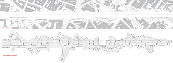
The contemporary city is involved in processes of globalization; they are the scenes of current technological, economical and cultural transformations. Areas are transformed into themed areas and different social groups are separated. I am interested in this border condition between the global and the local. The area of the urban analysis in Marseille is situated under and next to the highway [A7]. The highway divides the residential areas St-Mauront and La Joliette and has no function for the residents. Houses are demolished for the construction of the highway and the residential neighborhood is totally neglected. The area has not become a ‘non-place’; it has great qualities for the residents. People are using this area in many different ways, it has become a lively place with interaction between different social groups. The area can be seen as Le Corbusier’s ‘Plan Obus’; integration of different cultures, architectural styles and life-styles are granted, by the coexistence in the same huge infrastructure. Future plans are to demolish a part of the highway and to make a boulevard with commercial buildings. The area would physically and socially be divided and the quality of the area is lost.
| Collage of functions
The area under and next to the highway is characterized by a collage of functions. Functions which have no relation with each other are situated next to each other. The whole area is filed with functions; while it is to be expected people would turn away from the highway. Apparently the area has ‘hidden’ qualities.
| Formal use; Informal use
Although the entire area is filled with formal functions, people are using the area in a different way. This informal use can exist in this area because it is not important for the local government in a cultural and economical way. For example; homeless people are banned out of the city center, to maintain the good reputation of the city. This area is not attractive for tourists and businessmen and therefore homeless people can live here. Places where Informal use is taking place are characterized by the lack of sight lines, they are ‘hidden’ places which can easily be overlooked when walking trough this area. In the area are also places where the informal use has taken over the formal use, for example; a parking places that look more like a dump yard then a parking place.
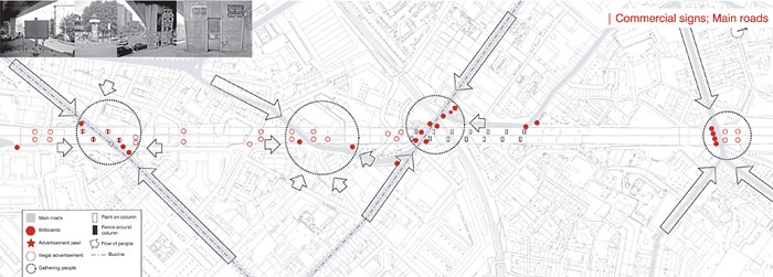
| Commercial signs; Main roads
The commercial signs are gathered along side the main roads in the area, where most people pass by. There is a lot of illegal advertisement in the area, but is only actively banned from areas next to main roads. At those places are rough texture paint and fences around columns preventing illegal advertisement. In contrast with paint, the fences are not very effective; illegal advertisement is stitched to the column above the fence.
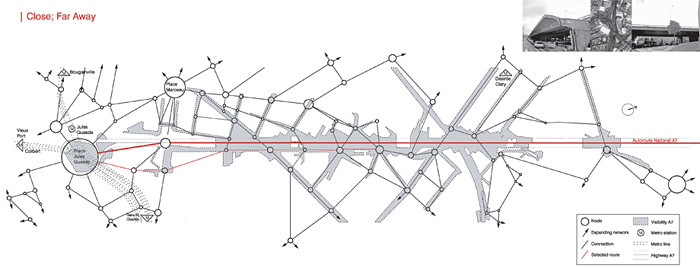
| Close; Far Away
The highway is clearly present in the neighborhood To access the highway, a detour must be taken. The highway is visual close, but physical far away.
| Two different worlds…
The areas on and under the highway A7 are two different worlds, not only different social groups [highway; tourists and businessmen, area under highway; local residents], but also in experience. The experience of driving on the highway is totally different from the experience of the area under the highway. The view on the highway is dominated by the Notre Dame de la Garde. The experience of the area under the highway is more fragmented, a lot of places with different atmospheres can be found here next to each other.
| Factors of control
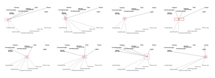
There are a lot of factors [facades, fences, lights, cameras] present in the area that determine the control of it. Fences are situated around all functions [public and private]. They function in a different way; as a visual border between two areas, to exclude people from privatized areas or for safety reasons [football and basketball court]. There are many blind facades in the area, partly because of demolished parts of housing blocks for construction of the highway. Areas from where no windows can be seen, gives the particular area an unsafe feeling. The lampposts are not sufficient to light the area at night, because of the many obstacles [fences, height differences, walls, trees, etc.]. Some privatized areas and public functions like squares have good lightning, but in most areas it is unpleasant to walk at night.
|Heightmap
The differences in height are important for the experience of the area. The height varies between 2.5 and 20 meters and this is only the case under the highway. Some places provide a magnificent view over the area, others are extremely introverted.
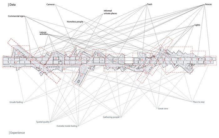
| Data and Experience map
The area is divided in 20 places which can be seen as rooms in the building, each place has its own atmosphere. By combining my experiences in the area and the collected data, relations become visible. Several places have the potential to become lively places, but are now dominated by a negative experience. The preconditions are already present to make it a valuable place for the local community. The future plans to demolish a part of the highway and to make a boulevard with commercial buildings, would physically and socially divide the neighborhood and is therefore not valuable for the local community.
‘De Terp’ Living in the City
No photos available right now.
Please verify your settings, clear your RSS cache on the Slickr Flickr Admin page and check your Flickr feed
In de ontwerpopgave is de terp een metafoor, maar tevens een begrip. Als metafoor is de terp te lezen als een plateau met vormen, als begrip is het een bindend element. Elke vormstudie bestaat uit een horizontaal element (het basement) en vertikale elementen die daardoor heen gaan. Vormstudie 01 is een plateau met 1 doorlopende vertikale vorm. Vormstudie 02 is een variant daarop. Vormstudie 03 is het basement een ring met daarin vertikale elementen. In vormstudie 04 is dit principe verder uitgewerkt. Er ontstaan interessante ruimtes tussen de torens en op het basement, met naar binnen- en naar buiten gerichte ruimtes. Vormstudie 04 heb ik als uitgangspunt voor het ontwerp genomen.
De kantoren bevinden zich op de begane grond en vormen een schil rond het binnengebied. De sportschool zit in het binnengebied op de beganegrond en is visueel afgesloten van de omgeving. In een sportschool kijken mensen in de spiegen en naar elkaar, het introverte karakter van het binnengebied versterkt dit. Via patio`s krijgt de sportschool lichttoetreding, ze versterken tevens de relatie met het dek. Via het dek worden de woningen in het basement en de woontorens ontsloten. Deze ruimte is verkeers- en verblijfsruimte. Om ruime woningen te kunnen maken zijn delen van de toren uitgeschoven, hierdoor krijgt iedere woning een prive buitenruimte. De renbaan bevind zich op het basement en is naar buiten gericht. Hij is toegangkelijk voor sportschool en bewoners. De woningen in het basement hebben buitenruimten op het basement.
Bookshop Faculty of Architecture, Delft
No photos available right now.
Please verify your settings, clear your RSS cache on the Slickr Flickr Admin page and check your Flickr feed
Onderdelen
Balie 1: Stylosbalie, brandblusser, Zitje: Zitplaats als de bookshop dicht is, Kast 1: Ruimte voor Stylos om spullen bij de balie te kunnen bergen, Uithangbord: Bord voor Stylos en de bookshop om promomateriaal op te hangen, Kast 2: Opberg kast voor abonnementen, binnen handbereik van de baliemedewerker,10 meter plankruimte, afgeschermd van de bezoekers, Balie 2: bookshopbalie, bevat computer, geldkluisje(lade), pinautomaat, aftekenschriften, lade met kantoorartikelen, Kast 3 t/m 6: Bevat 30 verschillende boeken, 30 verschillende vakjes en 10 verschillende tijdschriften, 5 verschillende vakjes, Bankje: Te gebruiken als bookshop open [om boeken in te kijken] en dicht is.
Architectonische kwaliteit
“Door de openheid en toegankelijkheid vormt de bookshop een verlevendiging dat in het verlengde ligt met het concept van de hal [straat van Bouwkunde]” Het object heeft een sterk karakter met een eigen identiteit, maar past tegelijkertijd goed in zijn omgeving.
Locatie
Oude locatie was goed, analyse laat oude locatie ook zien, op die locatie past die tevens in context van de faculteit.
Flexibiliteit en verplaatsbaarheid
Als de bookshop open gaat worden de schuifdeuren die voor de boekenkast zitten voor de openingen geschoven zodat er een ingang ontstaat. Als de bookshop dicht gaat worden de schuifdeuren weer teruggeschoven en doet het object dienst als zithoek.
Doordat het ontwerp uit onderdelen bestaat zijn deze los te koppelen en te verplaatsen. Zo kunnen de onderdelen worden opgeborgen of ergens anders van dienst zijn als dat nodig mocht zijn.
Tegengaan van diefstal
De balie is op sta-hoogte waardoor de verkoper en beter overzicht krijgt en een actievere houding heeft. Als de bookshop open is zijn de schuifdeuren voor de boekenkasten weg, deze blokkeren nu alle openingen behalve de hoofdingang. Door de balie naast die ingang te leggen heeft de verkoper een beter beeld van wie er naar binnen dan wel naar buiten gaat. Als laatste zullen de bezoekers van de bookshop zich aan de regel moeten houden dat er geen tassen naar binnen mogen, deze kunnen in de vakken naast de ingang gelegd worden (deze regel geldt immers ook in de bibliotheek).
Bouwtijd in de faculteit
Doordat het ontwerp uit verschillende onderdelen bestaat, worden deze in een werkplaats in elkaar gezet. De verschillende onderdelen worden vervolgens naar binnen gebracht en op een simpele manier aan elkaar gekoppeld. Zie ook flexibiliteit / verplaatsbaarheid.
Arthotel, Rotterdam
No photos available right now.
Please verify your settings, clear your RSS cache on the Slickr Flickr Admin page and check your Flickr feed
The Waterfront of Rotterdam was the most important part of Rotterdam around the 1900s, politically as well as economically. The activities at the Waterfront are no longer there and the city center is now the most important part of Rotterdam. The Waterfront is an undefined space at the moment, but it has lots of potential to become a lively area again. This area is the link between the Maas and the city center. There are plans to create a cultural, tourist and recreational city center of Rotterdam at the Maas, between the Erasmus- and Willemsbridge. These plans are embedded in the ‘Ruimtelijk Plan Rotterdam’.
Rotterdam is a city rich of different kinds of art and culture; theatre, dance, music, film, photo, video, architecture, literature, festivals, museums, exhibitions and performance art.
The qualities of the Waterfront can be exploited by an art hotel, in which artists produce art with the city of Rotterdam as inspiration. The waterfront has a soothing function. It is possible for the artist to retreat here and work in silence. The expositions of the produced art are positive for the city of Rotterdam in many ways:
– a relation between the city center and the waterfront is created
– people are forced to think about the future of the city through the eyes of the different artists
– in a period of ten years the waterfront will be upgraded and new ideas about the possibilities of the waterfront will emerge.
Through the location of the art hotel an attempt is made to exploit the qualities of the waterfront. The building should play a role in the discussion about the future of Rotterdam, this is the reason why the location at the ‘Boompjes’ between the Erasmus bridge and the Willemsbridge has been chosen. The largest contrast can be found at this location between the busy city center and the calm riverside of the Maas, this enhances the concept of the hotel. The main road of the ‘Boompjes’ is not seen as an obstacle, but is being used to reach a large audience, it is possible to show projections on the front for example. The rooms/ workshops are orientated at the Maas, this way the artists can process their impressions and inspirations of the city center in their quiet workshops at the riverside. The road at right angles to the Maas in height of the hotel forms the visual connection between the city and the hotel.
Stadskantoor, Meppel
No photos available right now.
Please verify your settings, clear your RSS cache on the Slickr Flickr Admin page and check your Flickr feed
Inleiding
Voor dit afstudeerproject hebben we een ontwerp uitgewerkt van de Zwarte Hond Architecten. Het is ontworpen voor een prijsvraag en aangezien de Zwarte Hond Architecten 2e is geworden, wordt het niet verder uitgewerkt, zodat we het project voor ons afstuderen konden gebruiken. Het ontwerp betreft een Stadskantoor in het centrum van Meppel, wat gebaseerd is op het binnenstadsplan Meppel 2015. Volgens de Zwarte Hond Architecten moet het gebouw geassocieerd worden met stijlvol en sober, met een open en informeel karakter, in een sfeer die verantwoordelijk, nuchterheid en dienstbaarheid uitstraalt. Dit uitgangspunt zal een bijzonder gebouw opleveren waarin allerlei ruimtelijke en functionele oplossingen mogelijk zijn. Er moet ook plaats zijn voor onbepaaldheden en interpretaties. Het is een gebouw zonder ‘muren’ tussen werkruimten en publieksruimten, tussen bestuurders en ambtenaren en tussen de overheid en bevolking. Een open en transparant gebouw dat duurzaam mooi is.
Architectonisch concept
Uitgangspunt is een ontwerp waarbij stedenbouw, architectuur, publieke ruimte, kantoorconcepten, naast duurzaamheid een gebouw vormen. Door extra verdiepingshoogte, vides over meerdere verdiepingen, in ruime mate toetreding van licht en lucht ontstaan er mooie zichtlijnen die voor de samenhang zorgen.
Beeld bepalend aan de Grote Oever is de toren waaronder verzonken in het maaiveld, de Raadshal ligt. De centrale hal is aan een zijde gekoppeld aan de hoger gelegen verdiepingen van de toren waar het bestuur gehuisvest is. Aan de andere zijde verbindt de hal alle verdiepingen van het overige gebouw. De liften en trappen lopen door een open verbinding naar de parkeerkelder.Op de begane grond zijn alle balie functies ondergebracht die zijn gekoppeld aan de achterliggende kantoren. De magazijnen en opslagruimten liggen deels ondergronds en zijn bereikbaar vanaf de noordzijde. De eerste verdieping kan naast de lift bereikt worden door een flauw hellende trap die vanaf de hal naar boven loopt, hier zijn het bedrijfsrestaurant en de vergaderzalen geplaatst. De kantoorvleugel op de tweede en derde verdieping, waarin zich het merendeel van de werkplekken bevindt, heeft een balkon aan de hal.


